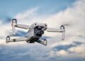
Drones are no longer just gadgets for hobbyists; they’ve taken centre stage in environmental monitoring, especially when it comes to tackling climate change. “Environmental Monitoring: Drones Tracking Climate Change” dives into how these nimble flyers are reshaping the way we collect critical data on our planet. By offering a bird’s-eye view, drones help gather information on everything from glacial melt rates to forest health. This shift represents a significant evolution in the drone industry, where these unmanned systems are contributing to sustainable practices. In this blog, you’ll uncover what makes drones indispensable for climate scientists and why this marriage of technology and nature is paramount for our future. Ready to soar into the details?
How Are Drones Tracking Climate Change?
Imagine a tool that soars above our beautiful planet, keeping an eye on how everything changes. That’s where “Environmental Monitoring: Drones Tracking Climate Change” comes into play. It’s all about using advanced drone technology to watch and study our environment, particularly focusing on the impacts of climate change. These high-flying machines gather data that helps scientists understand what’s happening to our world. With climate change being such a hot topic, drones are proving to be incredibly valuable in this field.Here’s what you’ll find when diving deeper into this fascinating world:
-
– Precision Data Collection: Drones capture high-resolution images and gather precise data, providing a detailed view of environmental changes. Whether it’s glacial melt or shifting wildlife patterns, drones offer unparalleled insight.
- Understanding Drone Navigation Systems
- GPS and Sensors: Most drones rely on GPS technology and a range of sensors to accurately navigate the skies. GPS allows drones to establish their position in real time, ensuring a steady course and the capability to return to their starting point effortlessly.
- Gyros and Accelerometers: Gyroscopes and accelerometers monitor the drone’s movement and orientation, helping it maintain equilibrium during flights—crucial for stability in windy conditions.
- Obstacle Detection and Avoidance: Many modern drones come equipped with cameras and sonar tools that help identify and circumvent obstacles. These features are incredibly important for safe flights, both outdoors and in confined spaces.
- System Integration: Advanced drone systems integrate data from these components to automate flight paths. Through dedicated software apps, users can pre-plan routes or manoeuvres, enhancing automation and efficiency.
- GPS and Sensors: Most drones rely on GPS technology and a range of sensors to accurately navigate the skies. GPS allows drones to establish their position in real time, ensuring a steady course and the capability to return to their starting point effortlessly.
- Features for Varied Users
- Beginner Modes: Many drones offer simplified controls or ‘beginner modes’ to assist new pilots in gaining confidence and mastering flight skills.
- Advanced Flight Capabilities: On the other hand, seasoned drone enthusiasts can take advantage of advanced flight capabilities like autonomous flight patterns, camera angling, or speed adjustments.
- Beginner Modes: Many drones offer simplified controls or ‘beginner modes’ to assist new pilots in gaining confidence and mastering flight skills.
- Applications in Various Industries
- Delivery and Logistics: Drones are pushing boundaries in delivery services, offering quicker and more efficient parcel disbursement, especially in hard-to-reach areas.
- Film and Photography: With high-definition camera integration, drones capture stunning aerial views, revolutionising the film and photography industries by providing unique perspectives.
- Surveying and Mapping: Drones equipped with mapping software and sensors are indispensable in surveying lands, assisting in urban planning, environmental conservation, and construction.
- Delivery and Logistics: Drones are pushing boundaries in delivery services, offering quicker and more efficient parcel disbursement, especially in hard-to-reach areas.
- Drones are actively used by researchers to track glacier melting rates, providing real-time data for climate models.
- Environmental agencies deploy drones to monitor air quality by measuring pollutant levels over large areas efficiently.
- Governments employ drones in forest management, helping to assess deforestation activities and restoring ecological balance.
- Conservationists frequently use drones to survey wildlife populations, especially in endangered habitats, without disturbing the environment.
- Industries leverage drone technology to inspect environmental compliance regarding emissions in agricultural and industrial zones, ensuring adherence to safety standards.
- Hobbyists support local environmental initiatives by using drones to monitor coastal erosions or support community-based conservation projects.
– Access to Remote Areas: These flying marvels can reach places that are otherwise difficult or dangerous for humans to explore. From dense forests to towering mountaintops, drones make the inaccessible accessible.
– Cost-Effectiveness: Compared to traditional methods, drones offer a cheaper alternative for monitoring large areas over extended periods. This economic efficiency makes extensive environmental monitoring more feasible.
– Real-Time Insights: With the ability to transmit data instantly, drones provide real-time insights, enabling quicker decision-making when urgent environmental changes occur. Imagine swiftly tracking a spreading wildfire’s path.
– Reduced Emissions: Unlike many other data collection methods, drones have a lower carbon footprint, aligning with sustainable practices and reducing our overall environmental impact.
As technology continuously evolves, drones stand at the forefront of environmental monitoring, making strides in studying and combating climate change. Fascinating, isn’t it? Let’s delve deeper into this remarkable synergy between technology and nature.
Drones Tracking Climate: Why It Matters
Drones in Environmental Monitoring
Pros and Cons of Climate Monitoring Drones
Pros of Environmental Monitoring: Drones Tracking Climate Change 1. Drones offer real-time data collection, providing immediate insights into environmental changes. 2. These devices access hard-to-reach areas, offering perspectives that ground-based equipment cannot. 3. They’re cost-effective, reducing the need for pricey traditional monitoring solutions. 4. Utilising drones helps minimise carbon emissions compared to conventional methods.Cons of Environmental Monitoring: Drones Tracking Climate Change 1. Limited Battery Life: Drones often struggle with short flight durations, affecting long-term monitoring missions. 2. Weather Vulnerability: They can be hampered by adverse weather conditions, limiting operational efficiency. 3. Data Management Challenges: Handling and analyzing vast amounts of data can become overwhelming and resource-intensive. 4. Regulatory Constraints: Compliance with safety regulations may restrict flight paths and operational capabilities.
Future of Drones in Climate Monitoring
As we look to the horizon, expect drones to advance with AI-enhanced sensors, new eco-friendly models debuting, and evolving regulations shaping how we use drones for addressing climate change.| Aspect | Details | 2023 | 2025 Forecast | 2027 Forecast |
|---|---|---|---|---|
| Drone Models | Top models by specs and price | Model A – £1,200 Model B – £950 |
Model C – £1,400 Model D – £1,100 |
Model E – £1,600 Model F – £1,250 |
| Regulations | Policy implementation timelines | Initial Proposal Stage | Reporting Phase | Full Implementation |
| Events | Attendance costs over the years | £150 | £180 | £200 |


