Drones, also known as unmanned aerial vehicles (UAVs), are becoming increasingly popular in various industries, including military, agriculture, surveying, photography, and many more. As the demand for drone technology increases, the need for more sophisticated navigation and control systems has emerged. This article will discuss the recent advancements in drone navigation and control systems, their benefits, and their potential applications.
Drone Navigation and Control Systems
GPS Navigation Systems
Global Positioning System (GPS) technology has been the backbone of drone navigation for many years. GPS systems use satellite signals to determine the drone’s location, altitude, and speed. They enable drones to navigate accurately and safely, even in harsh weather conditions. However, GPS technology has limitations, especially in urban areas or indoors, where satellite signals can be obstructed or weakened. To overcome these limitations, drone manufacturers have developed more advanced navigation systems that incorporate multiple sensors and technologies.
Computer Vision
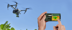
One of the most significant advancements in drone navigation and control systems is the incorporation of computer vision technology. Computer vision systems enable drones to “see” their environment and make decisions based on the visual data they receive. These systems use cameras and sensors to detect obstacles, recognize patterns, and navigate through complex environments. They can also be used for object detection and tracking, which is useful in surveillance, search and rescue, and agricultural applications.
Artificial Intelligence
Artificial intelligence (AI) has also played a significant role in improving drone navigation and control systems. AI algorithms enable drones to learn and adapt to their environment, making them more efficient and reliable. They can also be used for real-time data analysis, which is useful in agriculture, environmental monitoring, and disaster response. AI-powered drones can detect changes in soil moisture, plant health, and temperature, providing valuable insights for farmers and agronomists.
Obstacle Avoidance
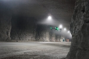
Obstacle avoidance is a crucial aspect of drone navigation, especially in urban areas or areas with many obstacles. Drone manufacturers have developed obstacle avoidance systems that use sensors and algorithms to detect and avoid obstacles. These systems can be either reactive or proactive. Reactive systems detect obstacles and change the drone’s path to avoid them. Proactive systems predict obstacles and plan a new path before the drone encounters them. Obstacle avoidance systems increase drone safety and reliability and enable them to operate in challenging environments.
Autonomous Navigation
Autonomous navigation is another significant advancement in drone technology. Autonomous drones can perform tasks without human intervention, making them useful in many applications. They can be used for aerial surveys, inspections, and deliveries, among others. Autonomous drones use sensors and algorithms to navigate, avoid obstacles, and perform tasks. They can also communicate with other drones and ground stations, making them ideal for swarm operations.
Precision Landing
Precision landing is an essential aspect of drone operations, especially in areas with limited landing space or high-risk environments. Drone manufacturers have developed precision landing systems that use sensors and algorithms to land drones accurately and safely. These systems enable drones to land on moving platforms, such as ships or vehicles, or in challenging environments, such as uneven terrain or tight spaces. Precision landing systems increase drone safety and enable them to operate in more demanding applications.
Wireless Charging
Wireless charging technology has also been developed for drones, which enables them to fly for longer periods without having to return to a charging station. Wireless charging uses electromagnetic induction to charge drones wirelessly, allowing them to operate in remote locations or areas with limited infrastructure. This technology is particularly useful in applications such as aerial surveys, environmental monitoring, and search and rescue.
Applications of Advanced Drone Navigation and Control Systems
The advancements in drone navigation and control systems have opened up new possibilities for drone applications. Here are some examples:
Agriculture
Advanced drone navigation and control systems can be used in agriculture for crop monitoring, yield prediction, and precision agriculture. Drones equipped with computer vision and AI can detect changes in soil moisture, plant health, and temperature, providing valuable insights for farmers and agronomists. They can also be used for precision spraying of fertilizers and pesticides, reducing waste and increasing crop yields.
Search and Rescue
Drone technology is increasingly being used in search and rescue operations, where time is of the essence. Drones equipped with computer vision and AI can search large areas quickly and provide real-time data to rescue teams. They can also detect and locate survivors in disaster zones or areas with difficult terrain. Autonomous drones can operate in swarm formations, making search and rescue operations more efficient and effective.
Delivery Services
The use of drones for package delivery is becoming increasingly popular, especially in areas with limited infrastructure or challenging terrain. Advanced navigation and control systems enable drones to navigate through complex environments, avoid obstacles, and perform precision landings. They can also communicate with other drones and ground stations, making them ideal for delivery services in urban areas.
Environmental Monitoring
Drones equipped with advanced navigation and control systems can be used for environmental monitoring, such as air quality, water quality, and wildlife surveys. They can provide real-time data to environmental agencies, enabling them to make informed decisions about environmental policies and actions. Autonomous drones can also be used for long-term monitoring of remote areas, such as forests or oceans.
However, with these advancements come some challenges that need to be addressed. One of the most significant challenges is the regulation of drone operations. Many countries have strict regulations for drone operations, especially in urban areas or areas with high population density. Drone manufacturers and operators need to ensure that their drones comply with these regulations to avoid fines or legal action.
Another challenge is the integration of drones into existing infrastructure, such as air traffic control systems. As the number of drones in the airspace increases, there is a need for more sophisticated systems to manage their operations and ensure their safety. Governments and regulatory agencies are working to develop systems to integrate drones into the airspace while ensuring the safety of other aircraft and people on the ground.
Conclusion
The advancements in drone navigation and control systems have opened up new possibilities for drone applications in various industries. GPS navigation systems have been the backbone of drone navigation for many years, but the incorporation of computer vision, AI, obstacle avoidance, autonomous navigation, precision landing, and wireless charging has improved drone safety, reliability, and efficiency. These technologies have enabled drones to perform tasks without human intervention, making them ideal for applications such as agriculture, search and rescue, delivery services, and environmental monitoring. As drone technology continues to evolve, we can expect to see more advanced navigation and control systems that will further enhance their capabilities and expand their applications.


