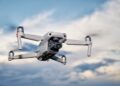
Over the past few decades, technology has revolutionized the way we do things, and surveying and mapping are no exceptions. Drones, also known as unmanned aerial vehicles (UAVs), are one of the most significant technological advances in recent times, with vast applications in various industries, including land surveying and mapping.
Drones for land surveying and mapping:
Traditionally, land surveying and mapping involved ground-based surveying, which was time-consuming and labour-intensive. Surveyors would have to walk around the area to be surveyed and measure distances and angles manually. This process was not only time-consuming, but it also led to inaccuracies in measurements and human errors. However, with the introduction of drones, surveying and mapping have become more efficient, accurate, and cost-effective.
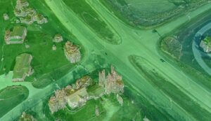
Drones can capture high-resolution aerial images and videos of the land, providing surveyors with a wealth of data that can be used to create detailed maps, topographical models, and 3D models of the land. Drones are equipped with high-definition cameras and sensors that can capture images and data in different spectrums, including thermal imaging, multispectral, and hyperspectral imaging. This capability enables surveyors to identify various features and objects on the land, such as buildings, vegetation, water bodies, and topography, among others.
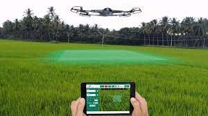
One of the most significant benefits of using drones for land surveying and mapping is the ability to cover large areas quickly and efficiently. With drones, surveyors can cover vast areas of land in a short period, providing accurate and detailed information. This capability is particularly useful in industries such as agriculture, where farmers need to monitor their crops and fields regularly. Drones can capture images of crops, which can be used to monitor crop health and identify any issues such as pest infestations or diseases.
Another benefit of using drones for land surveying and mapping is the improved accuracy of data. Drones can capture high-resolution images and data with high accuracy, resulting in more precise measurements and reduced errors. This improved accuracy is particularly crucial in industries such as construction and engineering, where accurate data is essential for planning and executing projects.
Furthermore, drones offer a significant cost-saving advantage compared to traditional surveying methods. The use of drones for land surveying and mapping eliminates the need for expensive equipment and labour, reducing the overall cost of the surveying process. Additionally, drones can access areas that are difficult or impossible to reach manually, reducing the risk of accidents and injuries, and lowering insurance costs.
Drones can also be used for environmental monitoring, particularly in areas that are difficult to access manually. For instance, drones can be used to monitor wildlife populations, track changes in the environment, and detect and prevent illegal activities such as poaching and deforestation. This capability is particularly useful in protecting endangered species and their habitats, conserving natural resources, and reducing environmental degradation.
Another significant advantage of using drones for land surveying and mapping is the ability to create detailed 3D models of the land. 3D models can provide a wealth of information that can be used for various applications, including urban planning, disaster management, and security. For example, 3D models can be used to simulate the impact of natural disasters such as floods and earthquakes, enabling authorities to plan and prepare for such events.
Despite the numerous benefits of using drones for land surveying and mapping, there are still some challenges that need to be addressed. One of the main challenges is the need for skilled operators who can fly and control drones effectively. Additionally, the use of drones for land surveying and mapping is subject to various regulations and restrictions, particularly in urban areas and near airports.
Conclusion
In conclusion, the use of drones for land surveying and mapping has revolutionized the way we collect and analyze data. Drones offer significant advantages such as improved accuracy, efficiency, cost savings, and the ability to access difficult-to-reach areas. The application of drones in land surveying and mapping has various potential benefits, including improving crop yields in agriculture, enhancing disaster management in urban planning, and conserving natural resources in environmental monitoring.
As technology continues to advance, the future of land surveying and mapping will rely heavily on the use of drones. Surveyors and mapping professionals need to embrace this technology and invest in the necessary equipment and training to take full advantage of its capabilities. Governments and regulatory bodies also need to develop policies and regulations that facilitate the safe and responsible use of drones in land surveying and mapping.
In summary, drones have transformed the traditional methods of land surveying and mapping, providing a more efficient, accurate, and cost-effective approach to collecting and analyzing data. Their ability to capture high-resolution aerial images, cover large areas quickly, and create detailed 3D models make them an invaluable tool for surveyors and mapping professionals. While there are challenges that need to be addressed, the benefits of using drones for land surveying and mapping are undeniable, and the future of the industry will undoubtedly depend on their continued application.
Looking ahead, there is no doubt that drones will continue to revolutionize land surveying and mapping. With advancements in technology, drones are becoming more sophisticated, enabling them to collect more data and perform more complex tasks. For example, drones are now equipped with lidar technology, which can generate highly accurate 3D maps of the land surface, allowing surveyors to create precise elevation models and contour lines.
In addition, the use of drones in land surveying and mapping is becoming more widespread, with more industries recognizing the benefits they offer. For instance, the mining industry is using drones to survey mines and gather data on mineral deposits, while the construction industry is using drones to monitor building sites and track progress. As more industries adopt drone technology, the demand for skilled operators and surveyors will continue to grow.
Furthermore, the integration of drones with other technologies such as artificial intelligence (AI) and machine learning (ML) is creating new possibilities for land surveying and mapping. By analyzing the data collected by drones using AI and ML, surveyors can identify patterns and trends that were previously difficult to detect. This capability has the potential to revolutionize land surveying and mapping, allowing for more accurate and insightful data analysis.
In conclusion, the benefits of using drones for land surveying and mapping are clear. Drones offer significant advantages in terms of efficiency, accuracy, and cost savings, making them invaluable tools for surveyors and mapping professionals. As technology continues to advance, drones will become even more sophisticated, enabling them to collect more data and perform more complex tasks. The future of land surveying and mapping depends on the continued application of drone technology and the development of new and innovative ways to collect and analyze data.