Drones, also known as unmanned aerial vehicles (UAVs), have gained popularity in recent years for their ability to capture aerial imagery, videos, and data. While drones are commonly used in military applications, they also have significant benefits in agriculture and surveying. In this article, we will explore the benefits of drones in agriculture and surveying.
Agriculture
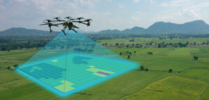
Drones can be used to monitor crop health and growth. This is accomplished through the use of sensors, cameras, and other monitoring equipment that can be attached to the drone. The data collected can be used to assess the health of the crops and identify areas where the crops may need additional care or treatment.

Drones can also be used to assess soil health and fertility. Soil samples can be collected by attaching sensors to the drone, and the data collected can be used to identify areas where the soil may be deficient in certain nutrients. This information can be used to improve the overall health and yield of the crops.
Drones can also be used for precision agriculture. Precision agriculture is the practice of using technology to manage crops and increase their yield. Drones can be used to monitor crops and collect data that can be used to make informed decisions about the use of fertilizers, pesticides, and other inputs.
Drones can also be used for planting and spraying crops. This is accomplished through the use of seeders and sprayers that can be attached to the drone. Drones can be programmed to fly over a field and plant or spray crops in a precise and efficient manner.
Surveying
Drones can be used for land surveying. This is accomplished through the use of cameras and sensors that can be attached to the drone. The data collected can be used to create maps and models of the land, which can be used for a variety of purposes, including construction, land management, and environmental monitoring.
Drones can also be used for building inspections. This is accomplished by attaching cameras and sensors to the drone and flying it over the building. The data collected can be used to identify areas where the building may be in need of repair or maintenance.
Drones can also be used for infrastructure inspections. This is accomplished by attaching cameras and sensors to the drone and flying it over bridges, highways, and other infrastructure. The data collected can be used to identify areas where the infrastructure may be in need of repair or maintenance.
Benefits
The use of drones in agriculture and surveying has several benefits. These benefits include:
Efficiency: Drones can cover large areas of land in a short amount of time. This can save time and money compared to traditional methods of monitoring crops and surveying land.
Accuracy: Drones can collect data with a high degree of accuracy. This can provide valuable information about crop health and soil fertility, as well as the condition of buildings and infrastructure.
Safety: Drones can be used to inspect buildings and infrastructure without the need for workers to climb ladders or scaffolding. This can improve worker safety and reduce the risk of accidents.
Environmental impact: Drones can be used to monitor the environment and identify areas where there may be pollution or other environmental hazards. This can help to protect the environment and prevent damage to natural resources.
Cost-effective: Drones are cost-effective compared to traditional methods of surveying and agriculture. This can make it easier for small farmers and landowners to access this technology and improve their crop yields or manage their land more effectively.
Improved crop yields: Drones can help farmers to identify areas of their crops that are not growing as well as they should be. This information can be used to make changes to irrigation, fertilization, or other factors that affect crop growth. As a result, farmers can improve their crop yields and reduce waste.

More precise mapping: Drones can collect data about land features, such as topography and vegetation, at a much higher resolution than traditional surveying methods. This allows for more precise mapping and modeling of land areas, which can be useful for a range of applications, including land-use planning, construction, and environmental monitoring.
Early detection of pests and disease: Drones can be used to monitor crops for signs of pests or disease. Early detection of these problems can help farmers to take action to prevent their spread and minimize damage to their crops.
Improved safety in surveying: Traditional surveying methods often require surveyors to work in hazardous or difficult-to-reach locations, such as near highways or on steep terrain. Drones can be used to collect data from these areas without putting surveyors at risk.
Faster response to natural disasters: Drones can be used to quickly assess the damage caused by natural disasters, such as hurricanes, floods, or wildfires. This information can be used to coordinate emergency response efforts and allocate resources more effectively.
However, it’s important to note that there are also potential drawbacks and challenges associated with the use of drones in these fields. For example, regulations around drone use can vary by location and can be restrictive in some areas. There may also be concerns around privacy and data security, particularly when drones are used for surveillance purposes.
To address these issues, it’s important for drone operators and users to be aware of regulations and guidelines around drone use in their area. Additionally, they should take steps to ensure that any data collected is stored securely and used in a responsible and ethical manner.
In conclusion, the benefits of drones in agriculture and surveying are numerous and diverse. From improving crop yields to enhancing safety and efficiency in surveying, drones offer a range of advantages that can help farmers, landowners, and surveyors to work more effectively and sustainably. As the technology continues to evolve and become more widely available, we can expect to see even more innovative uses for drones in these fields. However, it is important to keep in mind the potential drawbacks and challenges associated with drone use and to ensure that these technologies are used responsibly and ethically.


