Exploring the world of drones in real estate is an exciting journey, showcasing how technology transforms our perspective—literally! “Drones in Real Estate: Capturing Stunning Property Views” dives into this dynamic application, illustrating the enthralling shift in how properties are marketed and sold. With high-resolution aerial shots and virtual tours, drones offer a unique vantage point that enhances property listings, providing potential buyers with an immersive experience from their screen. This article delves into flight performance, safety regulations, and the impact of drones on both buyer behaviour and environmental factors. It’s perfect for tech enthusiasts and industry professionals eager to discover how drones are reshaping real estate marketing. Whether you’re a drone aficionado or just curious, there’s plenty to learn and enjoy!
How Are Drones Changing Real Estate Photography?
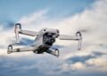
Hold onto your hats and cameras because drones are transforming the real estate landscape! “Drones in Real Estate: Capturing Stunning Property Views” dives into how these flying marvels are revolutionising property marketing. Imagine aerial shots capturing expansive estates, intricate roofing, and sprawling gardens, all rendered in stunning detail. Real estate agents can showcase properties like never before, offering a perspective that was once exclusive to helicopters but is now accessible and affordable thanks to drones. Isn’t that exciting?When it comes to selecting the right gear, let’s talk drones. For real estate photography, drones with high-resolution cameras and stable gimbals are essential. Models like the DJI Phantom 4 or Mavic Air 2 are fan favourites. They provide crisp, 4K video quality that captures the essence of a property. The ease of flying these drones allows anyone to operate them with little practice. However, before you take off, remember safety and regulations are key.
In terms of regulations, drone operators must comply with the Civil Aviation Authority (CAA) guidelines. It’s crucial to have permission from the property owner and avoid restricted areas. Flying below 400 feet and maintaining line-of-sight is imperative for safety. The last thing a drone operator wants is a legal hiccup while capturing million-pound views!
Here are five stellar advantages of drones in real estate:
– Enhanced Visuals: Capturing angles and views not possible with traditional photography.
– Cost Efficiency: Cheaper than hiring helicopters or airplanes for aerial shots.
– Up-to-Date Listing: Quickly update listings with fresh images and videos.
– Buyer Engagement: Engages potential buyers through immersive video tours and bird’s-eye views.
– Market Edge: Stand out in the competitive market with unique and engaging presentations.
Drones aren’t just a tech trend; they’re reshaping how the real estate industry operates, leading to quicker sales and happier clients. Whether for a sprawling country home or a city flat, drones are adding a new dimension to real estate, one stunning property view at a time!
How Drones Enhance Real Estate with Stunning Views
- Understanding Drone Navigation Systems
- GPS and Sensors: Most drones rely on GPS technology and a range of sensors to accurately navigate the skies. GPS allows drones to establish their position in real time, ensuring a steady course and the capability to return to their starting point effortlessly.
- Gyros and Accelerometers: Gyroscopes and accelerometers monitor the drone’s movement and orientation, helping it maintain equilibrium during flights—crucial for stability in windy conditions.
- Obstacle Detection and Avoidance: Many modern drones come equipped with cameras and sonar tools that help identify and circumvent obstacles. These features are incredibly important for safe flights, both outdoors and in confined spaces.
- System Integration: Advanced drone systems integrate data from these components to automate flight paths. Through dedicated software apps, users can pre-plan routes or manoeuvres, enhancing automation and efficiency.
- GPS and Sensors: Most drones rely on GPS technology and a range of sensors to accurately navigate the skies. GPS allows drones to establish their position in real time, ensuring a steady course and the capability to return to their starting point effortlessly.
- Features for Varied Users
- Beginner Modes: Many drones offer simplified controls or ‘beginner modes’ to assist new pilots in gaining confidence and mastering flight skills.
- Advanced Flight Capabilities: On the other hand, seasoned drone enthusiasts can take advantage of advanced flight capabilities like autonomous flight patterns, camera angling, or speed adjustments.
- Beginner Modes: Many drones offer simplified controls or ‘beginner modes’ to assist new pilots in gaining confidence and mastering flight skills.
- Applications in Various Industries
- Delivery and Logistics: Drones are pushing boundaries in delivery services, offering quicker and more efficient parcel disbursement, especially in hard-to-reach areas.
- Film and Photography: With high-definition camera integration, drones capture stunning aerial views, revolutionising the film and photography industries by providing unique perspectives.
- Surveying and Mapping: Drones equipped with mapping software and sensors are indispensable in surveying lands, assisting in urban planning, environmental conservation, and construction.
- Delivery and Logistics: Drones are pushing boundaries in delivery services, offering quicker and more efficient parcel disbursement, especially in hard-to-reach areas.
Real-World Use Cases in Real Estate
1. Enhanced Property Photography: Real estate agents use drones to capture aerial shots and unique angles of properties, promoting listings with stunning visuals.2. Virtual Tours Creation: With drones, 360-degree virtual tours become a reality, allowing potential buyers to explore properties remotely.
3. Land Surveying: Drones assist in mapping out large properties, providing precise measurements and details for developers and buyers.
4. Roof and Structure Inspection: Agents and inspectors deploy drones for detailed inspection of rooftops and other hard-to-reach areas, without risk or extensive costs.
5. Marketing Video Production: Producing engaging video content using drones helps highlight architectural features, landscapes, and locations, attracting more interest from prospective buyers.
6. Showcasing Neighborhoods: Drones offer a bird’s-eye view of surrounding amenities and the neighbourhood, adding context and appeal to the property listings.
Pros & Cons of Real Estate Drone Use
Pros of Drones in Real Estate: Capturing Stunning Property Views 1. Offers a bird’s-eye perspective, enhancing property appeal. 2. Provides detailed imagery, showcasing unique property features. 3. Saves time compared to traditional photography methods. 4. Increases marketing potential, attracting more buyers.Cons
- Initial cost of drones can be high, making it a hefty investment for small real estate firms.
- Weather conditions like strong winds and rain can disrupt drone operations, leading to schedule delays.
- Privacy concerns can arise in residential areas, requiring careful planning and adherence to regulations.
Future Trends in Drone Real Estate Photography
In the coming months, anticipate cutting-edge drone models with enhanced aerial imaging capabilities, shifts in real estate drone regulations, and emerging trends that blend virtual reality with drone technology to transform property showcases.html
| Aspect | Version/Model | Specs | Price | Upgrade Changes |
|---|---|---|---|---|
| Drone Models | DJI Phantom 4 | 20MP Camera, 30 min Flight Time | £1,200 | Improved Obstacle Sensing |
| DJI Mavic 3 | 4/3 CMOS Hasselblad Camera, 46 min Flight Time | £1,599 | Longer Battery Life, Superior Camera Quality | |
| Regulations | Before 2025 | Basic UAV Certification | n/a | Stricter No Fly Zones |
| After 2025 | Advanced UAV Certification | n/a | Broader Operational Limits | |
| Events | 2019 | n/a | £200 | Standard Industry Panels |
| 2023 | n/a | £300 | Interactive Workshops Added |


